

Chester County Covered Bridges
by Michael Pilligalli, Editor
The first covered bridge in Pennsylvania was said to be erected and open for usage on January 1, 1805. It crossed the Schuylkill River in what is now downtown Philadelphia. Its finished cost was said, at the time, to be $300,000. In our beloved Chester County, the first recording of a covered bridge was built in the area southwest of Marshallton in 1807. Between 1800 and 1821, there are recorded to have been nineteen covered bridges erected over water bodies throughout our state. And interestingly it only took ten years from 1946 to 1956, for a total of 217 out of a state total of 488 bridges to disappear from the landscapes. Lancaster County had the largest number of in use covered bridges and Chester County was the fourth ranking. Between the first in 1807 and the end of the century, 1899, there were 77 erected in Chester County proper and 21 other covered bridges which spanned water into different states or counties. Jump to 1976, and the total number of in use covered bridges in Chester County had dwindled to seventeen.
In our quadrant for Chester County Day 2023, there were a total of nineteen covered bridges spanning the French Creek, Pickering Creek, and the Schuylkill River. Today 5 of those are still standing.

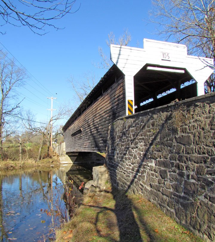
Valley Forge Knox Bridge
“This bridge is part of the Valley Forge National Park so it is protected as a National Registered Structure.”
Probably the most popular for painters and photographers is the Valley Forge Knox Bridge. It crosses Valley Creek which flows into the Schuylkill about a mile and a half away. The name may have derived from one of two sources. First possibility was two term United States Senator from Pennsylvania, Philander C. Knox, who bought 256 acres in that area and built a comfortable and spacious dwelling along the creek within view of the bridge. The second choice was that it was named for General Henry Knox from the Revolutionary War. He became Washington’s Secretary of War after the Revolution but, in the 1777-1778 time period, while at Valley Forge, he lived in a dwelling along the Valley Creek where the bridge was first erected in 1851. The naming of the bridge may be a mystery but, accurately, it is known in the books as Bridge No. 165. At $843.00, the first bridge on the sight of the Valley Forge Dam, was built by Ferdinand Wood in 1851. It lasted until a flood on the river took it down in 1865. Robert Russell took on the responsibility of replacing it with a longer span over its original 50 feet to make it 65 feet long and 13 feet wide. It copied its predecessor as it was in the Burr Arch design of construction and built of white pine. It was built for the sum of $1,179. In 1958, the bridge met with another disaster, this time by fire. Fire and wooden bridges do not go well together, but thanks to the local police and fire fighters, all was not completely lost. This time around our wooden bridge was strengthened with steel girders, possibly coming from the nearby Phoenix Iron and Steel Company close by in Phoenixville. It is a part of Valley Forge National Park so is protected as a National Registered Structure.

Rapp’s Bridge sits over the French Creek, built in 1866.
Next of the five remaining in our area this year is about two miles from downtown Phoenixville. Rapp’s Bridge sits over the French Creek, was built in 1866, and is known in “the books” as County Bridge No. 188. George Rapp was a grist and sawmill owner in the area, and it is said that the bridge was named for him and his businesses which provided so many in the area with jobs. The bridge contains a marble maker indicating the date, the names of the County Commissioners serving at that time and the builder’s name, Benjamin F. Hartman. It is one of only two covered bridges in Chester County still having its marble sign hanging in the bridge wing wall. Built in 1866, it cost $3,595.50. Its span was longer than the Knox bridge by almost double, 122 feet. It was also known at the time that the builder’s wife’s maiden name was Rapp and that that may have helped George Hartman get his carpentry skills noticed to become the builder of said bridge. Hurricane Agnes blew through our region in 1972, and a part of the bridge and the road leading to its entrance were destroyed. The Highway Department received about $7,000 from federal relief funds to have it repaired. At that point on June 18, 1973, it was added to the list of the National Register of Historic Places. Fast forward to 2011, and the maintenance of the bridge, along with general repairs amounted to a whopping $1,500,000. The bridge was closed to crossing traffic by 2014.
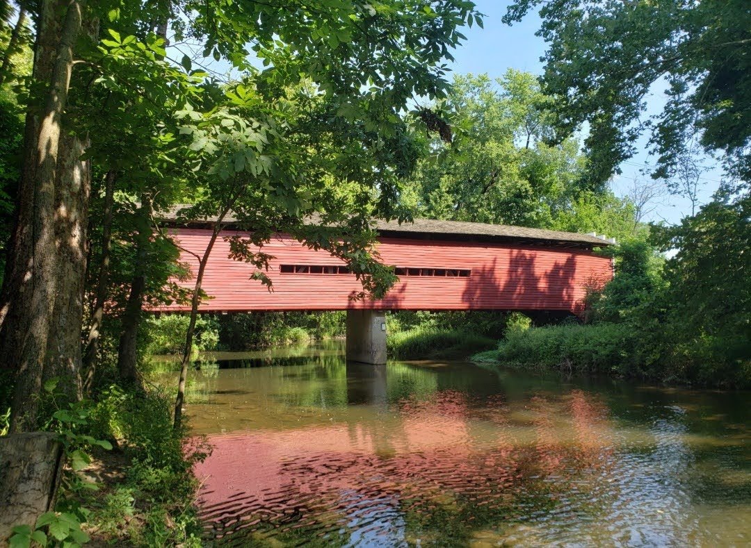
Kennedy’s Bridge, built in 1856.
A straight mile away from Rapp’s Bridge and two miles or so by canoe is Kennedy’s Bridge. Although built by Alex Kennedy and Jesse King, the Kennedy Bridge sign at the southern entry way proclaims it was built by both men for the County Commissioners: Newton Nichols, William Maitland, and Albert Way. It was contracted to be built on July 4, 1856, and it took less than ninety days to construct, being finished on October 1, 1856. Alexander Kennedy owned 202 acres on the north side of the bridge, and he farmed his land and raised livestock. Jesse King lived nearby and was the local carpenter. The bridge had a 100 foot span and a fourteen foot roadway and was built for the grand total of $2,149. It also featured a Burr Arch interior construction technique and white pine material. It suffered some major damage after a flood in 1884 and was repaired and then reinforced with steel in 1936. This is checked off as County Bridge No. 190 and it was listed on the National Register of Historic Places on January 21, 1974.
Sheeder-Hall Bridge, spans the area of French Creek and/or Birch Run. Chester County’s Oldest Covered Bridge.
Chester County’s oldest covered bridge is the Sheeder-Hall Bridge which spans the area of French Creek and /or Birch Run; there is a fine line to determine which one it spans as they flow so closely together at the point of the bridge. This is another dual named bridge. This time for Henry Hall ,who owned a large farm on the West Vincent side of the bridge, and Henry Sheeder, who owned and ran an iron forge on the French Creek. His family later also operated a paper mill from 1833 through 1916 about a half mile above the bridge location. The Sheeder Post Office served the area from 1889 to 1935. This was a family in the area who deserved to have a bridge named for their contributions to the area. The 100 foot span of the bridge was built by Robert Russell and Jacob Fox in 1850 at the cost of $1564. Mr Russell was a noted bridge builder in Chester County, and it seems that this may have been Mr. Fox’s first and last venture at bridge building. Even though it was our first covered bridge, it is listed as County Bridge No. 194. It was placed on the National Register of Historic Places on April 23, 1973.
Larkin’s Covered Bridge, by Choess, in the Marsh Creek area, 1854.
Moving over to the Marsh Creek area we get to see Larkin’s Covered Bridge. The first bridge was built over Marsh Creek in 1854. In 1860, Jesse Larkin purchased an established paper mill on the water and converted it to a grist mill. His home and the mill were a stones throw from the bridge at the time. For over 100 years the bridge was known as Larkin’s Covered Bridge or County Bridge No. 128. The bridge needed to be rebuilt in 1881 and that was the job of Ferdinand Wood and his brother Menander. The cost then was $893. Again, they still incorporated the Burr Arch design in its construction and its span was 65 feet and its roadway within was 14.5 feet. Its opening inside the bridge was 12.5 feet tall. It resided peacefully in its location until 1972, when Chester County Water Resources Authority purchased 1,265 acres which was drained by Marsh Creek. Over 500 acres of that purchase today are underwater including the area which Larkin’s Bridge spanned. A contract was signed with a house mover company for $19,200 to move the bridge intact to its new location. The new concrete foundations for each end cost an additional $6,685. In 1998, Uwchlan Township acquired the bridge and in 2006, it was dismantled and moved yet again to a new site. It now commands a lovely view of a trail path and was included on the National Register of Historic Places on December 10, 1980.
Theodore Burr from Connecticut was the man who is credited with devising the Burr Arch building design of covered bridges in our area. Built by quality craftsman, these bridges were usually built with local, available white pine, no nails, even though one of the largest nail factories was in Phoenixville, hand built without power tools, and with grit and determination to have them represent our area and last through the years. That principal worked as we can still appreciate many of those built in historic Chester County.

The Burr Arch Design
Burr, a Connecticut native is credited with devising the Burr Arch building design of all the covered bridges in our area.